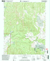
2002 Map of Central East
USGS Topo · Published 2005About this map
Pine Valley and the community of Central serve as the primary human anchors on this landscape dominated by the eastern reaches of the Dixie National Forest. The Santa Clara River winds through the valley, flanked by Mahogany Valley and several high-altitude landmarks such as Atchinson Mountain and Harrison Peak. Significant local-history identifiers include the Pine Valley Chapel, a local Cem, and the Pine Valley Visitor and Work Center. The area's reliance on essential water sources is clearly documented through numerous labels for locations like Mountain House Spring, Eightmile Spring, and Indian Spring. Evidence of early infrastructure and resource extraction is found in the Cinder Pit, Gravel Pit, and various 4wd tracks and the Summit Trail that navigate the varied terrain of Fourmile Bench and Grassy Flat.
Find a feature on this map
61 named features on this map. Tap any name to fly to it.
Don’t see what you’re looking for? This feature index may not catch every label — zoom into the map to look around manually.
Map Details
Editions of this 2002 Central East Map
This is the sole edition of this map. No revisions or reprints were ever made.
Other maps of this area

1885 · St. George
USGS Topo · 1:250,000

1891 · St. George
USGS Topo · 1:250,000

1950 · Iron Mountain
USGS Topo · 1:62,500

1950 · Page Ranch
USGS Topo · 1:24,000

1951 · Page Ranch
USGS Topo · 1:24,000

1953 · Cedar City
USGS Topo · 1:250,000

1957 · New Harmony
USGS Topo · 1:62,500

1958 · Cedar City
USGS Topo · 1:250,000

1962 · Cedar City
USGS Topo · 1:250,000
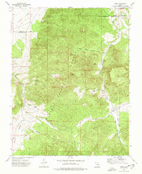
1972 · Pinto
USGS Topo · 1:24,000