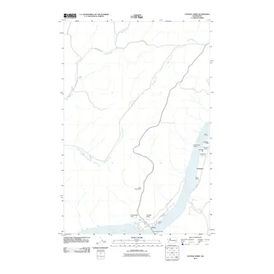
2011 Map of Central Ferry
USGS Topo · Published 2011About this map
The Snake River corridor defines this landscape at Lake Bryan, where transportation and agricultural research meet the water's edge. This 2011 survey highlights the infrastructure surrounding the Central Ferry Bridge, including the small settlements of Peyton and Central Ferry. The presence of the Central Ferry Research Farm and the Fort of Central Ferry indicates the area's ongoing significance as a hub for both history and modern science. Along the eastern banks, specialized terrain features like Hastings Bar and Willow Landing sit near Lewellen Gulch and Hammer Gulch. To the north and west, the map follows the winding paths of Alkali Flat Creek and Mud Flat Creek, crisscrossed by rural arteries such as Selbu Church Rd and Church Hill Rd that serve the high plateau country.
Find a feature on this map
25 named features on this map. Tap any name to fly to it.
Don’t see what you’re looking for? This feature index may not catch every label — zoom into the map to look around manually.
Map Details
Editions of this 2011 Central Ferry Map
This is the sole edition of this map. No revisions or reprints were ever made.
Other maps of this area

1950 · La Crosse
USGS Topo · 1:62,500

1950 · Penawawa
USGS Topo · 1:62,500

1950 · Endicott
USGS Topo · 1:62,500

1950 · Hay
USGS Topo · 1:62,500

1952 · Hay
USGS Topo · 1:62,500

1952 · La Crosse
USGS Topo · 1:62,500

1955 · Pullman
USGS Topo · 1:250,000

1958 · Pullman
USGS Topo · 1:250,000

1981 · Dusty
USGS Topo · 1:24,000
1981 · La Crosse West
USGS Topo · 1:24,000