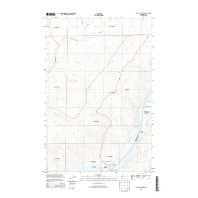
2014 Map of Central Ferry
USGS Topo · Published 2014About this map
The Snake River carves a deep valley through the high plateau of the Palouse, serving as the primary geographic and economic corridor for this portion of the Washington interior. This terrain is defined by a network of steep draws and gulches, such as Red Rock Draw and Lewellen Gulch, which feed into the river valley. The river crossing at Central Ferry remains the focal point of the area, anchored by the Central Ferry Bridge and the nearby Peyton settlement. Historically significant riverfront locations like Willow Landing and Hastings Bar suggest the long-standing reliance on the waterway for transport and agriculture.
Find a feature on this map
30 named features on this map. Tap any name to fly to it.
Don’t see what you’re looking for? This feature index may not catch every label — zoom into the map to look around manually.
Map Details
Editions of this 2014 Central Ferry Map
This is the sole edition of this map. No revisions or reprints were ever made.
Other maps of this area

1950 · La Crosse
USGS Topo · 1:62,500

1950 · Penawawa
USGS Topo · 1:62,500

1950 · Endicott
USGS Topo · 1:62,500

1950 · Hay
USGS Topo · 1:62,500

1952 · Hay
USGS Topo · 1:62,500

1952 · La Crosse
USGS Topo · 1:62,500

1955 · Pullman
USGS Topo · 1:250,000

1958 · Pullman
USGS Topo · 1:250,000

1981 · Dusty
USGS Topo · 1:24,000
1981 · La Crosse West
USGS Topo · 1:24,000