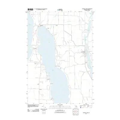
2011 Map of Central Lake
USGS Topo · Published 2011About this map
Torch Lake and Lake Michigan define this narrow corridor of Antrim County, where glacial geography created a sequence of connected waterways. The village of Central Lake sits at the junction of Hanley Lake and Intermediate Lake, connected by the Intermediate River. This survey captures the region's recreational and agricultural character, featuring the YMCA Camp on Hayo-Went-Ha Point and the A-Ga-Ming Golf Course overlooking the eastern shore of Torch Lake. Smaller settlements like Eastport and Creswell are documented alongside local landmarks such as Torchport Airport and the prominent Old Baldy dune. Genealogy and local history researchers can locate several burial grounds, including Lake View Cemetery, Bay View Cemetery, Southern Cemetery, and Russell Cemetery, which are scattered throughout the townships to serve these lakeside communities.
Find a feature on this map
100 named features on this map. Tap any name to fly to it.
Don’t see what you’re looking for? This feature index may not catch every label — zoom into the map to look around manually.
Map Details
Editions of this 2011 Central Lake Map
This is the sole edition of this map. No revisions or reprints were ever made.
Other maps of this area

1954 · Central Lake
USGS Topo · 1:62,500

1954 · Traverse City
USGS Topo · 1:250,000

1955 · Cheboygan
USGS Topo · 1:250,000

1956 · Mancelona
USGS Topo · 1:62,500

1957 · Elk Rapids
USGS Topo · 1:62,500

1958 · Cheboygan
USGS Topo · 1:250,000

1958 · Traverse City
USGS Topo · 1:250,000

1961 · Boyne City
USGS Topo · 1:62,500

1975 · Mancelona NW
USGS Topo · 1:24,000

1975 · Boyne City NW
USGS Topo · 1:24,000