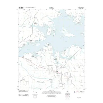
2011 Map of Centre
USGS Topo · Published 2011About this map
Centre serves as the focal point of this Cherokee County survey, where the Coosa River and the expansive waters of Weiss Lake dominate the landscape. The geography is defined by the intricate shoreline of the lake, which encircles landmarks like Hog Island and Buffingtons Island. Modern residential development is evident in several lakeside communities, including Yellow Creek View Subdivision and Big Nose Creek Subdivision. In the more rural stretches, the map preserves the location of numerous family and community burial grounds such as Tates Chapel Cemetery and Chestnut Cemetery. Along the southern border, Terrapin Creek joins the river system near Garrett Bridge, while the northwest corner features the natural drop of Yellow Creek Falls. The presence of the Centre Municipal Airport and Weiss Dam highlights the mid-century infrastructure that transformed the local economy from strictly agricultural to one supported by hydroelectric power and regional transit.
Find a feature on this map
161 named features on this map. Tap any name to fly to it.
Don’t see what you’re looking for? This feature index may not catch every label — zoom into the map to look around manually.
Map Details
Editions of this 2011 Centre Map
This is the sole edition of this map. No revisions or reprints were ever made.
Other maps of this area

1893 · Fort Payne
USGS Topo · 1:125,000

1898 · Fort Payne
USGS Topo · 1:125,000

1900 · Fort Payne
USGS Topo · 1:125,000

1946 · Portersville
USGS Topo · 1:24,000
1947 · Portersville
USGS Topo · 1:24,000

1955 · Rome
USGS Topo · 1:250,000

1958 · Rome
USGS Topo · 1:250,000

1961 · Rome
USGS Topo · 1:250,000

1963 · Rome
USGS Topo · 1:250,000
1967 · Gaylesville
USGS Topo · 1:24,000