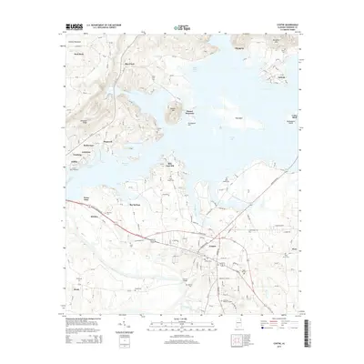
2014 Map of Centre
USGS Topo · Published 2014About this map
Centre serves as the focal point of this Alabama landscape, situated where the terrain transitions from the heights of Lookout Mountain and Shinbone Ridge into the expansive waters of Weiss Lake. The map reveals a complex shoreline defined by Hawthorn Cove and Black Mallard Cove, created by the impoundment behind Weiss Dam. This modern geography overlays an older settlement pattern, as seen in the numerous family and community burial grounds like Neal Hill Cem and Pratt Cem that dot the countryside near Piney and Leesburg.
Find a feature on this map
162 named features on this map. Tap any name to fly to it.
Don’t see what you’re looking for? This feature index may not catch every label — zoom into the map to look around manually.
Map Details
Editions of this 2014 Centre Map
This is the sole edition of this map. No revisions or reprints were ever made.
Other maps of this area

1893 · Fort Payne
USGS Topo · 1:125,000

1898 · Fort Payne
USGS Topo · 1:125,000

1900 · Fort Payne
USGS Topo · 1:125,000

1946 · Portersville
USGS Topo · 1:24,000
1947 · Portersville
USGS Topo · 1:24,000

1955 · Rome
USGS Topo · 1:250,000

1958 · Rome
USGS Topo · 1:250,000

1961 · Rome
USGS Topo · 1:250,000

1963 · Rome
USGS Topo · 1:250,000
1967 · Gaylesville
USGS Topo · 1:24,000