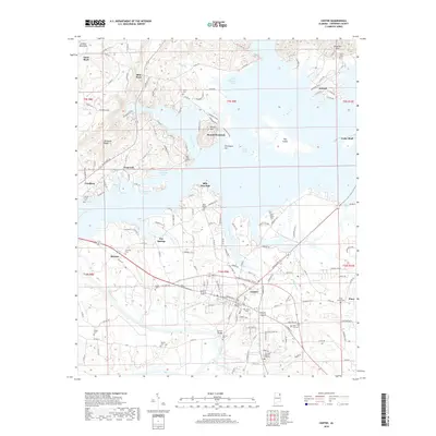
2018 Map of Centre
USGS Topo · Published 2018About this map
Centre serves as a focal point for this survey of Cherokee County, where the convergence of the Coosa River and its varied tributaries defines the local geography. The landscape is dominated by the sprawling reaches of Weiss Lake, which surrounds several islands and peninsulas, including Hog Island and Billy Goat Hill. To the west, the sharp rise of Shinbone Ridge and the southern edge of Lookout Mountain provide a dramatic contrast to the lowland coves and creeks. Genealogists can find significant local history in the numerous family and community burial grounds, such as Garrett Cem, Sewell Cem, and Shiloh Cem. The map traces the growth of established settlements like Leesburg and Cedar Bluff, connected by a network of rural routes crossing the intricate waterways at points like Garrett Bridge. This late-2010s data reflects a modern era of lake-centered recreation and agriculture alongside preserved landmarks like the Cherokee Memory Gardens.
Find a feature on this map
186 named features on this map. Tap any name to fly to it.
Don’t see what you’re looking for? This feature index may not catch every label — zoom into the map to look around manually.
Map Details
Editions of this 2018 Centre Map
This is the sole edition of this map. No revisions or reprints were ever made.
Other maps of this area

1893 · Fort Payne
USGS Topo · 1:125,000

1898 · Fort Payne
USGS Topo · 1:125,000

1900 · Fort Payne
USGS Topo · 1:125,000

1946 · Portersville
USGS Topo · 1:24,000
1947 · Portersville
USGS Topo · 1:24,000

1955 · Rome
USGS Topo · 1:250,000

1958 · Rome
USGS Topo · 1:250,000

1961 · Rome
USGS Topo · 1:250,000

1963 · Rome
USGS Topo · 1:250,000
1967 · Gaylesville
USGS Topo · 1:24,000