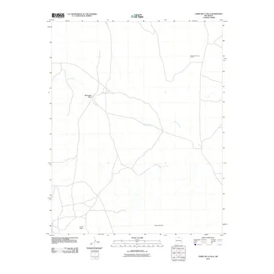
2010 Map of Cerro De La Olla
USGS Topo · Published 2010About this map
Mcgreggor Place sits within a high-elevation landscape in Taos County, defined by its isolation and the winding path of Arroyo Punche. This part of the Taos Plateau showcases a transition from volcanic features to the open range, where the prominent landmark of Cerro de la Olla rises above the surrounding terrain. The sparse human footprint on this 2010 survey emphasizes land use dedicated to ranching and wildlife management, as evidenced by the Mcgreggor Antelope Guzzler in the northern portion of the quadrangle. Other volcanic landforms like Cerrito Negro dot the southern reaches, marking the geological character of the region. The map reveals a network of local roads and unimproved tracks that connect these distant points across a high-desert environment that has seen little intensive development.
Find a feature on this map
5 named features on this map. Tap any name to fly to it.
Don’t see what you’re looking for? This feature index may not catch every label — zoom into the map to look around manually.
Map Details
Editions of this 2010 Cerro De La Olla Map
This is the sole edition of this map. No revisions or reprints were ever made.
Other maps of this area

1954 · Raton
USGS Topo · 1:250,000

1958 · Raton
USGS Topo · 1:250,000

1963 · Pinabetoso Peaks
USGS Topo · 1:24,000

1963 · Tres Piedras NE
USGS Topo · 1:24,000

1963 · Cerro De La Olla
USGS Topo · 1:24,000

1963 · Ute Mountain
USGS Topo · 1:24,000

1963 · Sunshine
USGS Topo · 1:24,000
1963 · La Segita Peaks NE
USGS Topo · 1:24,000
1963 · La Segita Peaks
USGS Topo · 1:24,000

1963 · Guadalupe Mountain
USGS Topo · 1:24,000