
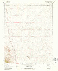
1963 Map of Pinabetoso Peaks
USGS Topo · Published 1967About this map
Pinabetoso Peaks rise above the high-desert borderland where the boundaries of Rio Arriba, Taos, and Conejos counties meet. This 1960s landscape is characterized by the physical remnants of earlier transportation networks, most notably the long stretch of the Old Railroad Grade that cuts north-south through the western portion of the quadrangle. Aside from this corridor and a few scattered Jeep Trails, the area appears remarkably undeveloped, save for the occasional well. The terrain is defined by its administrative intersections, including the Conejos Co Taos Co line at the New Mexico-Colorado border and the Rio Arriba Co Taos Co boundary. This map serves as a vital record for researchers tracing the path of former rail lines through this specific corner of the Southwest.
Find a feature on this map
6 named features on this map. Tap any name to fly to it.
Don’t see what you’re looking for? This feature index may not catch every label — zoom into the map to look around manually.
Map Details
Editions of this 1963 Pinabetoso Peaks Map
2 editions found
Other maps of this area

1918 · Tusas
USGS Topo · 1:125,000

1922 · Conejos
USGS Topo · 1:125,000

1945 · Durango
USGS Topo · 1:250,000

1953 · Durango
USGS Topo · 1:250,000

1954 · Durango
USGS Topo · 1:250,000

1954 · Raton
USGS Topo · 1:250,000

1954 · Trinidad
USGS Topo · 1:250,000

1954 · Aztec
USGS Topo · 1:250,000

1955 · Trinidad
USGS Topo · 1:250,000

1958 · Raton
USGS Topo · 1:250,000