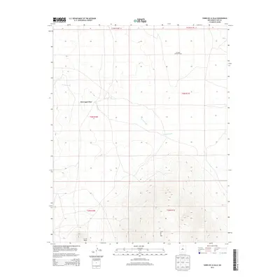
2013 Map of Cerro De La Olla
USGS Topo · Published 2013About this map
Cerro de la Olla dominates the southern landscape of this Taos County survey, rising significantly above the surrounding high plains. The topography here is defined by volcanic features and drainage patterns, including the prominent volcanic mound of Cerrito Negro in the southwest corner. The land use appears primarily rural and ranch-oriented, centered on the McGreggor Place settlement. Environmental management for local wildlife is evident through the presence of the McGreggor Antelope Guzzler in the northeastern reaches. The seasonal drainage of Arroyo Punche carves a path through the central and eastern sections, illustrating the arid hydrology of the region. This 2013 record provides a detailed look at the public land survey system divisions across several townships, documenting the modern footprint of these remote New Mexico highlands.
Find a feature on this map
11 named features on this map. Tap any name to fly to it.
Don’t see what you’re looking for? This feature index may not catch every label — zoom into the map to look around manually.
Map Details
Editions of this 2013 Cerro De La Olla Map
This is the sole edition of this map. No revisions or reprints were ever made.
Other maps of this area

1954 · Raton
USGS Topo · 1:250,000

1958 · Raton
USGS Topo · 1:250,000

1963 · Pinabetoso Peaks
USGS Topo · 1:24,000

1963 · Tres Piedras NE
USGS Topo · 1:24,000

1963 · Cerro De La Olla
USGS Topo · 1:24,000

1963 · Ute Mountain
USGS Topo · 1:24,000

1963 · Sunshine
USGS Topo · 1:24,000
1963 · La Segita Peaks NE
USGS Topo · 1:24,000
1963 · La Segita Peaks
USGS Topo · 1:24,000

1963 · Guadalupe Mountain
USGS Topo · 1:24,000