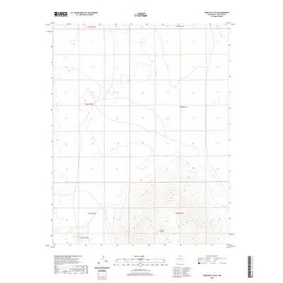
2020 Map of Cerro De La Olla
USGS Topo · Published 2020About this map
Cerro de la Olla dominates the southern landscape of this Taos County survey, rising significantly above the surrounding plateau. This prominent volcanic feature is complemented to the southwest by the smaller but distinct Cerrito Negro. The northern and central portions of the map are defined by the winding path of Arroyo Punche, which cuts through the high-altitude terrain typical of this part of New Mexico. The map illustrates a largely undeveloped landscape marked by section lines and townships including t30n r11e and t31n r10e. This 2020 edition provides a clear record of the area's natural topography, showing the elevation contours and drainage patterns that have shaped the land south of the Colorado border.
Find a feature on this map
9 named features on this map. Tap any name to fly to it.
Don’t see what you’re looking for? This feature index may not catch every label — zoom into the map to look around manually.
Map Details
Editions of this 2020 Cerro De La Olla Map
This is the sole edition of this map. No revisions or reprints were ever made.
Other maps of this area

1954 · Raton
USGS Topo · 1:250,000

1958 · Raton
USGS Topo · 1:250,000

1963 · Pinabetoso Peaks
USGS Topo · 1:24,000

1963 · Tres Piedras NE
USGS Topo · 1:24,000

1963 · Cerro De La Olla
USGS Topo · 1:24,000

1963 · Ute Mountain
USGS Topo · 1:24,000

1963 · Sunshine
USGS Topo · 1:24,000
1963 · La Segita Peaks NE
USGS Topo · 1:24,000
1963 · La Segita Peaks
USGS Topo · 1:24,000

1963 · Guadalupe Mountain
USGS Topo · 1:24,000