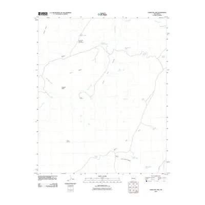
2010 Map of Cerro Del Oro
USGS Topo · Published 2010About this map
Cerro del Oro and the expansive Mesa del Oro dominate this high-desert landscape of Cibola County, where the topography is defined by complex arroyo systems and isolated ranching outposts. Water management is the primary narrative of the terrain, evidenced by the numerous catchment features like Horse Pasture Tank, Jonah Tank, and Seis-Wilson Detention Dam Number 1. Small-scale ranching life is centered around locations such as Orchard Place and Seis-Wilson Ranch, supported by vital water sources including Salado Spring and the Lonely Windmill. The map tracks the passage of Arroyo Colorado as it cuts through the mesas, alongside significant canyons like Cañon Palo Blanco. The southeastern corner shows the influence of Indian Rte 55 and the family-named landmarks Bill Aseyna Tank and Cañon Villa de Aseyna, providing a look at land use and livestock infrastructure in this arid region at the start of the 21st century.
Find a feature on this map
32 named features on this map. Tap any name to fly to it.
Don’t see what you’re looking for? This feature index may not catch every label — zoom into the map to look around manually.
Map Details
Editions of this 2010 Cerro Del Oro Map
This is the sole edition of this map. No revisions or reprints were ever made.
Other maps of this area

1917 · Cerro Verde
USGS Topo · 1:125,000

1917 · Broom Mountain
USGS Topo · 1:125,000

1954 · Socorro
USGS Topo · 1:250,000

1958 · Socorro
USGS Topo · 1:250,000

1960 · Cerro Verde
USGS Topo · 1:24,000

1961 · Marmon Ranch
USGS Topo · 1:24,000
1961 · East Mesa
USGS Topo · 1:24,000

1962 · Socorro
USGS Topo · 1:250,000

1964 · Field Ranch
USGS Topo · 1:24,000
1964 · Cerro Del Oro
USGS Topo · 1:24,000