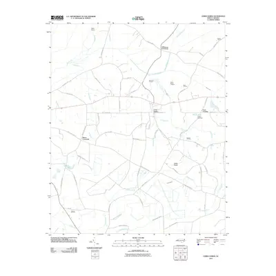
2010 Map of Cerro Gordo
USGS Topo · Published 2010About this map
Cerro Gordo sits at the heart of this coastal plain landscape, where a dense network of family-named roads and rural crossings defines the local geography. The area's agricultural and social history is reflected in the distribution of family burial grounds, such as Mount Moriah Cemetery, Bullard Cemetery, and Edwards Cemetery, often situated near prominent intersections like Williamson Crossroads and Hinson Crossroads. The drainage of the low-lying terrain is a dominant theme, characterized by the expansive Dunn Swamp and the headwaters of numerous watercourses, including Cow Branch and Greene Branch.
Find a feature on this map
61 named features on this map. Tap any name to fly to it.
Don’t see what you’re looking for? This feature index may not catch every label — zoom into the map to look around manually.
Map Details
Editions of this 2010 Cerro Gordo Map
This is the sole edition of this map. No revisions or reprints were ever made.
Other maps of this area

1943 · Pages Mill
USGS Topo · 1:62,500

1949 · Duford
USGS Topo · 1:24,000

1953 · Chadbourn
USGS Topo · 1:62,500

1953 · Florence
USGS Topo · 1:250,000

1954 · Florence
USGS Topo · 1:250,000

1962 · Fair Bluff
USGS Topo · 1:24,000

1962 · Fairmont
USGS Topo · 1:24,000
1962 · Tabor City West
USGS Topo · 1:24,000
1962 · Tabor City East
USGS Topo · 1:24,000

1962 · Fair Bluff
USGS Topo · 1:62,500