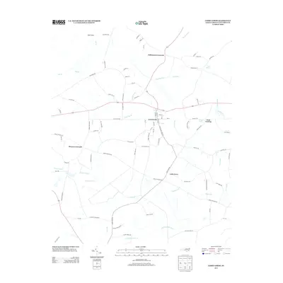
2013 Map of Cerro Gordo
USGS Topo · Published 2013About this map
Cerro Gordo serves as the central hub of this eastern North Carolina landscape, where a network of rural routes and watercourses defines the local geography. The topography is shaped by an intricate system of swampy lowlands and drainage branches, notably Dunn Swamp and Wolf Trap Br, which weave between small community clusters. The map illustrates a pattern of crossroads settlements typical of Columbus County, including Williamson Crossroads and Hinson Crossroads, while Cedar Grove is situated further south. Evidence of local industry and historical land use is preserved in names like Coleman Mill Br and the various family-named roads such as Dave Meares Rd and Porter Swamp Rd. This survey documents the transition from traditional creek-side settlements to a modern road network, maintaining a record of local family landmarks and hydrological features like Annetts Pond and Little Fresh Water Branch.
Find a feature on this map
87 named features on this map. Tap any name to fly to it.
Don’t see what you’re looking for? This feature index may not catch every label — zoom into the map to look around manually.
Map Details
Editions of this 2013 Cerro Gordo Map
This is the sole edition of this map. No revisions or reprints were ever made.
Other maps of this area

1943 · Pages Mill
USGS Topo · 1:62,500

1949 · Duford
USGS Topo · 1:24,000

1953 · Chadbourn
USGS Topo · 1:62,500

1953 · Florence
USGS Topo · 1:250,000

1954 · Florence
USGS Topo · 1:250,000

1962 · Fair Bluff
USGS Topo · 1:24,000

1962 · Fairmont
USGS Topo · 1:24,000
1962 · Tabor City West
USGS Topo · 1:24,000
1962 · Tabor City East
USGS Topo · 1:24,000

1962 · Fair Bluff
USGS Topo · 1:62,500