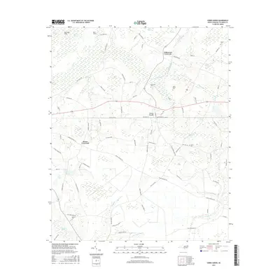
2016 Map of Cerro Gordo
USGS Topo · Published 2016About this map
Cerro Gordo serves as the primary hub of this eastern North Carolina landscape, where the long-standing rail line follows the corridor of Highway 76 through the heart of town. The area's settlement pattern is closely tied to its complex hydrology, with small communities and crossroads such as Williamson Crossroads and Hinson Crossroads positioned on higher ground between expansive wetland systems. These low-lying areas, including the massive Porter Swamp and Dunn Swamp, are fed by numerous small tributaries like Wolf Trap Br and Bridger Mill Branch. Local history is preserved in several family and community burial grounds, such as Mount Moriah Cem and Regar Cem, which are scattered among the agricultural fields. The terrain is further defined by distinctive geological features like Big Sandy Ridge and several Carolina bays, including Water Hole Bay and Sandy Fork Bay, which punctuate the coastal plain's flat reaches.
Find a feature on this map
95 named features on this map. Tap any name to fly to it.
Don’t see what you’re looking for? This feature index may not catch every label — zoom into the map to look around manually.
Map Details
Editions of this 2016 Cerro Gordo Map
This is the sole edition of this map. No revisions or reprints were ever made.
Other maps of this area

1943 · Pages Mill
USGS Topo · 1:62,500

1949 · Duford
USGS Topo · 1:24,000

1953 · Chadbourn
USGS Topo · 1:62,500

1953 · Florence
USGS Topo · 1:250,000

1954 · Florence
USGS Topo · 1:250,000

1962 · Fair Bluff
USGS Topo · 1:24,000

1962 · Fairmont
USGS Topo · 1:24,000
1962 · Tabor City West
USGS Topo · 1:24,000
1962 · Tabor City East
USGS Topo · 1:24,000

1962 · Fair Bluff
USGS Topo · 1:62,500