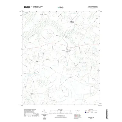
2019 Map of Cerro Gordo
USGS Topo · Published 2019About this map
Cerro Gordo serves as the central hub of this Columbus County landscape, where the local road network converges near the railroad tracks and a series of agricultural and swamp-bordering settlements. The geography is defined by an intricate system of bays and swamplands, including the prominent Porter Swamp and Duffie Swamp, which dictate the placement of rural homesteads and transit routes. Several family-named landmarks and rural congregations populate the area, such as the Cedar Grove church and numerous local burial grounds like Mount Moriah Cem and Gowans Cem. These small nodes of community, often situated at intersections like Williamson Crossroads and Hinson Crossroads, illustrate the persistent rural character of the region. The map captures a landscape where the natural drainage of features like Middle Swamp and Wolf Trap Br continues to shape the human footprint of timber and farming life.
Find a feature on this map
92 named features on this map. Tap any name to fly to it.
Don’t see what you’re looking for? This feature index may not catch every label — zoom into the map to look around manually.
Map Details
Editions of this 2019 Cerro Gordo Map
This is the sole edition of this map. No revisions or reprints were ever made.
Other maps of this area

1943 · Pages Mill
USGS Topo · 1:62,500

1949 · Duford
USGS Topo · 1:24,000

1953 · Chadbourn
USGS Topo · 1:62,500

1953 · Florence
USGS Topo · 1:250,000

1954 · Florence
USGS Topo · 1:250,000

1962 · Fair Bluff
USGS Topo · 1:24,000

1962 · Fairmont
USGS Topo · 1:24,000
1962 · Tabor City West
USGS Topo · 1:24,000
1962 · Tabor City East
USGS Topo · 1:24,000

1962 · Fair Bluff
USGS Topo · 1:62,500