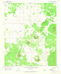
1967 Map of Cerro Hueco
USGS Topo · Published 1971About this map
The Continental Divide winds through this high-altitude landscape of Valencia County, marking a rugged boundary between watershed systems and volcanic formations. Much of the eastern terrain is dominated by the stark Lava flows of The Malpais, while the north and west are dotted with small ephemeral bodies of water such as Williams Lake, Big Lake, and Laguna de la Choza. Isolated volcanic cones rise abruptly from the plateau, including the namesake Cerro Hueco, Cerro Negro, and Cerrito Arizona.
Find a feature on this map
23 named features on this map. Tap any name to fly to it.
Don’t see what you’re looking for? This feature index may not catch every label — zoom into the map to look around manually.
Map Details
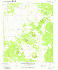
Editions of this 1967 Cerro Hueco Map
2 editions found
Other maps of this area

1886 · Wingate
USGS Topo · 1:250,000

1892 · Wingate
USGS Topo · 1:250,000

1952 · Valle Largo
USGS Topo · 1:24,000

1952 · Paxton Springs
USGS Topo · 1:24,000

1954 · Saint Johns
USGS Topo · 1:250,000

1954 · Gallup
USGS Topo · 1:250,000

1957 · Saint Johns
USGS Topo · 1:250,000

1958 · Gallup
USGS Topo · 1:250,000

1958 · Saint Johns
USGS Topo · 1:250,000

1959 · Gallup
USGS Topo · 1:250,000