
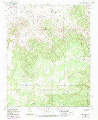
1961 Map of Cerro Parido
USGS Topo · Published 1963About this map
Sandoval Ranch and the related holdings of Joe Montoya Ranch and Ernest Montoya Ranch anchor this landscape of the New Mexico high desert. The 1961 survey illustrates a region defined by complex topography and strategic water management, where numerous tanks such as Heifer Tank and Seco Tank supported livestock grazing across the Ignacio Chavez Grant Boundary. The northern portion of the Cibola National Forest dominates the southern half of the sheet, characterized by deep incisions like Cañon Blanco and prominent rises such as Cerro Parido. Evidence of early natural resource interests appears near Arroyo Azabache at Coal Spring, suggesting a history of local prospecting. The mapping of Ojo Azabache and various springs highlights the critical importance of water sources in navigating the transition between high mesas and the canyon floors.
Find a feature on this map
38 named features on this map. Tap any name to fly to it.
Don’t see what you’re looking for? This feature index may not catch every label — zoom into the map to look around manually.
Map Details
Editions of this 1961 Cerro Parido Map
2 editions found
Other maps of this area

1883 · Mt. Taylor
USGS Topo · 1:250,000

1886 · Mt. Taylor
USGS Topo · 1:250,000

1892 · Mt. Taylor
USGS Topo · 1:250,000

1899 · Mt. Taylor
USGS Topo · 1:250,000

1958 · Albuquerque
USGS Topo · 1:250,000

1961 · Cerro Tinaja
USGS Topo · 1:24,000

1961 · El Dado Mesa
USGS Topo · 1:24,000

1961 · Mesita Del Gavilan
USGS Topo · 1:24,000

1961 · Arroyo Empedrado
USGS Topo · 1:24,000
1961 · Canada Calladita
USGS Topo · 1:24,000