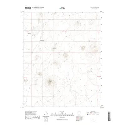
2020 Map of Cerro Pomo
USGS Topo · Published 2020About this map
Volcanic landforms and high-desert terrain dominate this portion of the Eastern Navajo Agency, defined by a series of prominent peaks and ridgelines. The landscape is punctuated by distinct geological features such as Cerros de Las Mujeres and the central summit of Cerro Pomo. These volcanic markers provided essential navigational points for travelers across the arid plateau, as seen in the alignment of Peñasco Ridge and the broad expanse of Peñasco Flat.
Find a feature on this map
18 named features on this map. Tap any name to fly to it.
Don’t see what you’re looking for? This feature index may not catch every label — zoom into the map to look around manually.
Map Details
Editions of this 2020 Cerro Pomo Map
This is the sole edition of this map. No revisions or reprints were ever made.
Other maps of this area

1954 · Saint Johns
USGS Topo · 1:250,000

1957 · Saint Johns
USGS Topo · 1:250,000

1958 · Saint Johns
USGS Topo · 1:250,000

1962 · Saint Johns
USGS Topo · 1:250,000

1967 · Red Lake Mission
USGS Topo · 1:24,000
1967 · Cerro Brillante
USGS Topo · 1:24,000

1967 · Chimney Hill
USGS Topo · 1:24,000

1967 · Cerro Alto
USGS Topo · 1:24,000

1967 · Veteado Mountain
USGS Topo · 1:24,000
1967 · Cerro Pomo
USGS Topo · 1:24,000