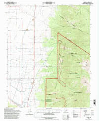
1995 Map of Cerro
USGS Topo · Published 1997About this map
Sunshine Valley transitions from the irrigated agricultural plains of the west into the high peaks of the Sangre de Cristo Mountains to the east during the mid-1990s. The landscape is defined by an intricate network of water management, where the Sunshine Ditch, Llano Ditch, and several numbered canals like Canal No 1 and Canal No 2 support the settlements of Cerro and El Rito. This mapping reveals the human effort to channel runoff from the mountains into the arid valley, evidenced by the numerous ditches and the Main Lateral.
Find a feature on this map
42 named features on this map. Tap any name to fly to it.
Don’t see what you’re looking for? This feature index may not catch every label — zoom into the map to look around manually.
Map Details
Editions of this 1995 Cerro Map
This is the sole edition of this map. No revisions or reprints were ever made.
Other maps of this area

1954 · Raton
USGS Topo · 1:250,000

1958 · Raton
USGS Topo · 1:250,000

1963 · Costilla
USGS Topo · 1:24,000

1963 · Amalia
USGS Topo · 1:24,000

1963 · Cerro
USGS Topo · 1:24,000

1963 · Ute Mountain
USGS Topo · 1:24,000

1963 · Sunshine
USGS Topo · 1:24,000

1963 · Questa
USGS Topo · 1:24,000

1963 · Guadalupe Mountain
USGS Topo · 1:24,000

1963 · Latir Peak
USGS Topo · 1:24,000