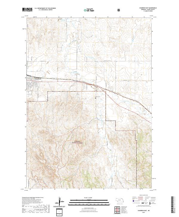
2021 Map of Chadron East
USGS Topo · Published 2021About this map
Chadron sits at the western edge of this landscape where the Nebraska High Plains meet the dramatic escarpments of the Nebraska National Forest. The map detail traces the transition from the city's structured grid, including E 10th St and Ridgeview Rd, into the complex drainage systems of Bordeaux Cr and its tributaries. The eastern edge of the forest is marked by a network of recreational and historic paths, including the Spotted Tail Trl and the Spotted Tail Overlook Trl, which navigate the elevation changes south of the city. Evidence of early rural infrastructure and community life is found at the Highland Cem and the Cowboy Trl, the latter following a former rail corridor. Water management for the arid region is visible at Marshall Reservoir in the north, while the winding courses of Big Bordeaux Cr and Little Bordeaux Cr define the local topography.
Find a feature on this map
43 named features on this map. Tap any name to fly to it.
Don’t see what you’re looking for? This feature index may not catch every label — zoom into the map to look around manually.
Map Details
Editions of this 2021 Chadron East Map
This is the sole edition of this map. No revisions or reprints were ever made.
Other maps of this area

1955 · Alliance
USGS Topo · 1:250,000

1957 · Alliance
USGS Topo · 1:250,000

1958 · Alliance
USGS Topo · 1:250,000

1966 · Chadron 3 NE
USGS Topo · 1:24,000

1969 · Chadron NE
USGS Topo · 1:24,000

1969 · Bordeaux
USGS Topo · 1:24,000
1970 · Bohemian Creek
USGS Topo · 1:24,000

1970 · Chadron 3 NW
USGS Topo · 1:24,000
1970 · Chadron East
USGS Topo · 1:24,000
1970 · Isinglass Buttes
USGS Topo · 1:24,000