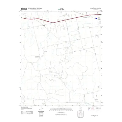
2012 Map of Chalk Peak
USGS Topo · Published 2012About this map
The Bankhead Highway Historic District runs through the northern reaches of this West Texas landscape, mirroring the path of the interstate near Trent. This corridor represents a vital early transcontinental route, surrounded here by a grid of rural roads and the industrial footprint of the energy sector. The map documents multiple production areas including the White Flat Oil Field, Northwest Dora Oil Field, and the North Dora Oil Field, alongside the Grimes Gasoline Plant. These facilities are interspersed with small settlements and named locales such as Grimes, Tesco, and Herndon. Waterways like Noodle Cr and Stink Cr drain the terrain toward the south, where the eponymous Chalk Peak rises. Genealogy and local history researchers will find the White Church Cem and the Adrian Ranch noted among the sprawling ranchlands and oil patches.
Find a feature on this map
46 named features on this map. Tap any name to fly to it.
Don’t see what you’re looking for? This feature index may not catch every label — zoom into the map to look around manually.
Map Details
Editions of this 2012 Chalk Peak Map
This is the sole edition of this map. No revisions or reprints were ever made.
Other maps of this area

1893 · Roby
USGS Topo · 1:125,000

1893 · Sweetwater
USGS Topo · 1:125,000

1954 · Big Spring
USGS Topo · 1:250,000

1957 · Merkel
USGS Topo · 1:62,500

1957 · Noodle
USGS Topo · 1:62,500

1958 · Big Spring
USGS Topo · 1:250,000

1969 · Eskota
USGS Topo · 1:24,000

1969 · Holder Creek
USGS Topo · 1:24,000
1969 · Lake Sweetwater
USGS Topo · 1:24,000
1984 · Merkel West
USGS Topo · 1:24,000