
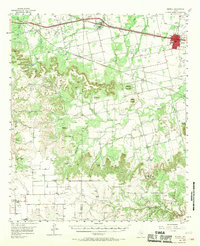
1957 Map of Merkel
USGS Topo · Published 1958About this map
The North Dora Oil Field and scattered drilling sites dominate the western upland of this Taylor County landscape, reflecting the mid-century petroleum expansion across the West Texas plains. The Texas and Pacific railroad corridor serves as the primary axis for development, anchoring the towns of Merkel and Trent alongside the War II Highway. These settlements provided essential hubs for the surrounding ranching and farming operations, evidenced by family-named landmarks like Rhodes Ranch and Adrian Ranch.
Find a feature on this map
42 named features on this map. Tap any name to fly to it.
Don’t see what you’re looking for? This feature index may not catch every label — zoom into the map to look around manually.
Map Details
Editions of this 1957 Merkel Map
2 editions found
Other maps of this area

1890 · Abilene
USGS Topo · 1:125,000

1891 · Anson
USGS Topo · 1:125,000

1892 · Abilene
USGS Topo · 1:125,000

1893 · Roby
USGS Topo · 1:125,000

1893 · Anson
USGS Topo · 1:125,000

1893 · Sweetwater
USGS Topo · 1:125,000

1954 · Big Spring
USGS Topo · 1:250,000

1954 · Abilene
USGS Topo · 1:250,000

1957 · Hawley
USGS Topo · 1:62,500

1957 · Noodle
USGS Topo · 1:62,500