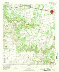
1957 Map of Merkel
USGS Topo · Published 1968About this map
Merkel and Trent anchor the northern corridor of this mid-century Taylor County survey, where the Texas and Pacific railroad and the Veterans World War II Highway cut a path across the West Texas landscape. The region transitions from the organized grid of these towns into a terrain defined by cattle ranching and energy extraction, most notably at the North Dora Oil Field. Notable family and community landmarks like Adrian Ranch, Rhodes Ranch, and Butman Camp are interspersed with several rural gathering places, including Pioneer Ch and White Church. The topography is punctuated by distinctive rises such as Blowout Mountain and Castle Peak, while the network of Mulberry Creek and Elm Creek provides the drainage for this high-plains cattle country.
Find a feature on this map
38 named features on this map. Tap any name to fly to it.
Don’t see what you’re looking for? This feature index may not catch every label — zoom into the map to look around manually.
Map Details
Editions of this 1957 Merkel Map
2 editions found
Other maps of this area

1890 · Abilene
USGS Topo · 1:125,000

1891 · Anson
USGS Topo · 1:125,000

1892 · Abilene
USGS Topo · 1:125,000

1893 · Roby
USGS Topo · 1:125,000

1893 · Anson
USGS Topo · 1:125,000

1893 · Sweetwater
USGS Topo · 1:125,000

1954 · Big Spring
USGS Topo · 1:250,000

1954 · Abilene
USGS Topo · 1:250,000

1957 · Hawley
USGS Topo · 1:62,500

1957 · Merkel
USGS Topo · 1:62,500