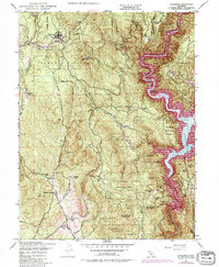
1948 Map of Challenge
USGS Topo · Published 1984About this map
The settlement of Challenge and the nearby Sharon Valley serve as the primary hubs in this mountainous portion of the northern Sierra Nevada foothills. Much of the landscape is defined by the Plumas National Forest and Tahoe National Forest, with a rugged interior punctuated by family-named landmarks such as Williams Ranch and Gochette Ranch. The presence of the Yuba Co Forestry Hdqrs and a Lookout Tower atop Oregon Pk highlights the region's historical focus on forest management and fire prevention.
Find a feature on this map
41 named features on this map. Tap any name to fly to it.
Don’t see what you’re looking for? This feature index may not catch every label — zoom into the map to look around manually.
Map Details
Editions of this 1948 Challenge Map
4 editions found
Other maps of this area

1888 · Smartsville
USGS Topo · 1:125,000

1888 · Bidwell Bar
USGS Topo · 1:125,000

1891 · Bidwell Bar
USGS Topo · 1:125,000

1891 · Smartsville
USGS Topo · 1:125,000

1892 · Smartsville
USGS Topo · 1:125,000

1893 · Bidwell Bar
USGS Topo · 1:125,000

1894 · Smartsville
USGS Topo · 1:125,000

1895 · Bidwell Bar
USGS Topo · 1:125,000

1895 · Smartsville
USGS Topo · 1:125,000

1897 · Bidwell Bar
USGS Topo · 1:125,000