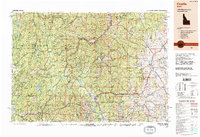
1989 Map of Challis
USGS Topo · Published 1989About this map
The Salmon River and its numerous tributaries dominate this late-twentieth-century landscape of Central Idaho, carving deep valleys through the Challis Mountains and the Sawtooth Range. This 1989 compilation details a region defined by extensive federal lands, including the Sawtooth National Recreation Area and parts of the Payette National Forest and Challis National Forest. Small settlements such as Challis, Stanley, and Clayton serve as the primary hubs connected by Route 75 and Route 93.
Find a feature on this map
51 named features on this map. Tap any name to fly to it.
Don’t see what you’re looking for? This feature index may not catch every label — zoom into the map to look around manually.
Map Details
Editions of this 1989 Challis Map
2 editions found
Other maps of this area

1891 · Bear Valley
USGS Topo · 1:125,000

1892 · Boise
USGS Topo · 1:125,000

1893 · Bear Valley
USGS Topo · 1:125,000

1894 · Squaw Creek
USGS Topo · 1:125,000

1894 · Idaho Basin
USGS Topo · 1:125,000

1894 · Rocky Bar
USGS Topo · 1:125,000

1895 · Hailey
USGS Topo · 1:125,000

1897 · Boise
USGS Topo · 1:125,000

1897 · Hailey
USGS Topo · 1:125,000

1900 · Sawtooth
USGS Topo · 1:125,000