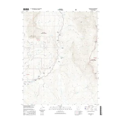
2016 Map of Chama Peak
USGS Topo · Published 2016About this map
The Continental Divide carves through this high-altitude landscape of Archuleta County, where the borders of the San Juan National Forest and Rio Grande National Forest meet. This terrain is defined by dramatic peaks, including Banded Peak, Chama Peak, and Navajo Peak, which tower over a network of mountain meadows like Virginia Meadow and Bear Meadow. The hydrology of the region is complex, featuring numerous alpine bodies of water such as Hidden Lake and the Price Lakes chain, alongside human-engineered water management features like King Ditch and Eaklor Ditch. Beneath the surface, the presence of the Oso Tunnel and Azotea Tunnel indicates significant water diversion or mining infrastructure common to this part of the San Juan Mountains. The map also records a variety of remote canyons, from Buckhammer Canyon to Wolcott Canyon, and flats like Weisel Flat, illustrating the diverse topography at the headwaters of the Navajo River.
Find a feature on this map
66 named features on this map. Tap any name to fly to it.
Don’t see what you’re looking for? This feature index may not catch every label — zoom into the map to look around manually.
Map Details
Editions of this 2016 Chama Peak Map
This is the sole edition of this map. No revisions or reprints were ever made.
Other maps of this area

1913 · Summitville
USGS Topo · 1:125,000

1915 · Summitville
USGS Topo · 1:125,000

1945 · Durango
USGS Topo · 1:250,000

1953 · Durango
USGS Topo · 1:250,000

1954 · Durango
USGS Topo · 1:250,000

1954 · Aztec
USGS Topo · 1:250,000

1955 · Chama
USGS Topo · 1:62,500

1955 · Lumberton
USGS Topo · 1:62,500

1957 · Chromo
USGS Topo · 1:62,500

1957 · Chama Peak
USGS Topo · 1:62,500