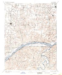
1890 Map of Chamois
USGS Topo · Published 1934About this map
The Missouri River serves as the central artery for this late 19th-century landscape, separating the rugged uplands of Callaway County from the rolling terrain of Osage and Gasconade. River towns such as Portland and Bluffton anchor the northern bank, while the Pacific Railroad tracks parallel the southern shore, connecting settlements like Chamois and Morrison. To the north, the Chicago and Alton Railroad services the county seat of Fulton, passing through agricultural tracts like the Nine Mile Prairie.
Find a feature on this map
114 named features on this map. Tap any name to fly to it.
Don’t see what you’re looking for? This feature index may not catch every label — zoom into the map to look around manually.
Map Details
Editions of this 1890 Chamois Map
5 editions found
Other maps of this area

1886 · Jefferson City
USGS Topo · 1:125,000

1888 · Tuscumbia
USGS Topo · 1:125,000

1890 · Louisiana
USGS Topo · 1:125,000

1890 · Mexico
USGS Topo · 1:125,000

1890 · Moberly
USGS Topo · 1:125,000

1890 · Hermann
USGS Topo · 1:125,000

1890 · Fulton
USGS Topo · 1:125,000

1894 · Tuscumbia
USGS Topo · 1:125,000

1894 · Jefferson City
USGS Topo · 1:125,000

1903 · Sullivan
USGS Topo · 1:125,000