1890 Map of Fulton
USGS Topo · Published 1904About this map
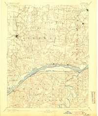
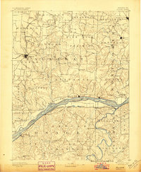
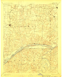
The Missouri River corridor serves as the central artery of this late 19th-century survey, dividing the landscape into distinct agricultural and upland regions. Along the northern banks, the Pacific Railroad connects riverfront settlements like Chamois and St. Aubert, while the northern interior is anchored by the county seat of Fulton and the upland expanse of Nine Mile Prairie. The map illustrates a complex network of creeks, such as Auxvasse Creek and Loutre Creek, which dictated the early placement of towns and river crossings.
Find a feature on this map
112 named features on this map. Tap any name to fly to it.
Don’t see what you’re looking for? This feature index may not catch every label — zoom into the map to look around manually.
Map Details
Editions of this 1890 Fulton Map
5 editions found

Other maps of this area

1886 · Jefferson City
USGS Topo · 1:125,000

1888 · Tuscumbia
USGS Topo · 1:125,000

1890 · Louisiana
USGS Topo · 1:125,000

1890 · Mexico
USGS Topo · 1:125,000

1890 · Moberly
USGS Topo · 1:125,000

1890 · Hermann
USGS Topo · 1:125,000

1890 · Fulton
USGS Topo · 1:125,000

1894 · Tuscumbia
USGS Topo · 1:125,000

1894 · Jefferson City
USGS Topo · 1:125,000

1903 · Sullivan
USGS Topo · 1:125,000