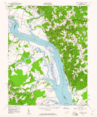
1943 Map of Champlain
USGS Topo · Published 1961About this map
Rappahannock River commerce and the surrounding plantation landscape of the Northern Neck define this 1943 survey. The river's importance to early Virginia transit is evident in the numerous landings and wharves, such as Carters Wharf, Smith Mount Landing, and Baird Landing, which served as vital connections between the water and the inland agricultural communities. The terrain transitions from the steep Fones Cliffs and high points like Bald Eagle Hill down to the vast tidal marshes of Beverly Marsh and Otterburn Marsh. Inland, small settlements and rural institutions like Champlain and Leedstown are anchored by historic local congregations at St Mathews Ch, Ephesus Ch, and Rappahannock Ch. The detailed mapping of various necks, including Thomas Neck and Bottoms Neck, reveals a complex network of creeks and swamps that shaped the development of Essex, Westmoreland, and Richmond counties during the mid-20th century.
Find a feature on this map
58 named features on this map. Tap any name to fly to it.
Don’t see what you’re looking for? This feature index may not catch every label — zoom into the map to look around manually.
Map Details
Editions of this 1943 Champlain Map
2 editions found
Other maps of this area

1889 · Fredericksburg
USGS Topo · 1:125,000

1892 · Fredericksburg
USGS Topo · 1:125,000

1892 · Montross
USGS Topo · 1:62,500

1894 · Fredericksburg
USGS Topo · 1:125,000

1895 · Nomini
USGS Topo · 1:125,000

1895 · Montross
USGS Topo · 1:62,500

1898 · Nomini
USGS Topo · 1:125,000

1918 · Tappahannock
USGS Topo · 1:62,500

1918 · Aylett
USGS Topo · 1:62,500

1919 · Tappahannock
USGS Topo · 1:62,500