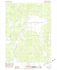
1983 Map of Champs Flat
USGS Topo · Published 1983About this map
Lassen National Forest encompasses this high-altitude landscape in Northern California, defined by volcanic features and isolated outposts. The interior of the plateau reveals a history of seasonal ranching and administrative sites, such as the Salt Cabin (Site) and Stones Headquarters (Site). The terrain transitions from the broad expanse of Champs Flat and Squaw Valley to significant peaks like Ashurst Mountain and Logan Mountain. Water is a critical resource in this arid mountain environment, evidenced by scattered improvements like Shays Hole Reservoir, Fleming Well, and McCoy Water Pit. The presence of the Cinder Pit near Burgess Flat highlights the geological character of the region, while isolated ranching operations are noted at Smith Cow Camp and Stanford Headquarters. This survey provides a clear view of the complex water management and grazing infrastructure used to support livestock in the high Sierras during the early 1980s.
Find a feature on this map
29 named features on this map. Tap any name to fly to it.
Don’t see what you’re looking for? This feature index may not catch every label — zoom into the map to look around manually.
Map Details
Editions of this 1983 Champs Flat Map
3 editions found
Other maps of this area

1886 · Honey Lake
USGS Topo · 1:250,000

1886 · Lassen Peak
USGS Topo · 1:250,000

1891 · Honey Lake
USGS Topo · 1:250,000

1892 · Lassen Peak
USGS Topo · 1:250,000

1893 · Honey Lake
USGS Topo · 1:250,000

1894 · Lassen Peak
USGS Topo · 1:250,000

1939 · Halls Flat
USGS Topo · 1:125,000

1955 · Westwood
USGS Topo · 1:250,000

1956 · Hayden Hill
USGS Topo · 1:62,500

1956 · Harvey Mtn
USGS Topo · 1:62,500