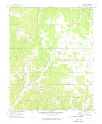
1972 Map of Chance
USGS Topo · Published 1974About this map
The settlement of Chance serves as the focal point for this 1970s topographic study of Adair County, revealing a landscape defined by deeply cut hollows and the winding paths of Tyner Creek and Jaybird Creek. The map documents a rural Ozark community where life centers around landmarks like New Hope Ch and its adjacent New Hope Cem. The southern portion of the sheet captures the northern edge of Westville and the Christie area, illustrating the transition from wooded ridges to more open valley floors. The naming conventions throughout the region, from Gray Squirrel Hol to Peacheater Creek, suggest a history closely tied to the natural environment and local hunting or farming traditions. Researchers can trace the network of secondary roads, including Ballard, which connected these disparate farmsteads and creek-side communities before modern infrastructure shifts.
Find a feature on this map
21 named features on this map. Tap any name to fly to it.
Don’t see what you’re looking for? This feature index may not catch every label — zoom into the map to look around manually.
Map Details
Editions of this 1972 Chance Map
This is the sole edition of this map. No revisions or reprints were ever made.
Other maps of this area

1898 · Tahlequah
USGS Topo · 1:125,000

1899 · Siloam Springs
USGS Topo · 1:125,000

1901 · Tahlequah
USGS Topo · 1:125,000

1903 · Siloam Springs
USGS Topo · 1:125,000

1904 · Siloam Springs
USGS Topo · 1:125,000

1905 · Tahlequah
USGS Topo · 1:125,000

1946 · Fort Smith
USGS Topo · 1:250,000

1954 · Tulsa
USGS Topo · 1:250,000

1958 · Tulsa
USGS Topo · 1:250,000

1963 · Tulsa
USGS Topo · 1:250,000