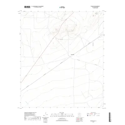
2019 Map of Chancellor
USGS Topo · Published 2019About this map
Chancellor is the primary settlement point in this arid stretch of Pecos County, situated at the intersection of a local rail line and the Old Alpine Hwy. The landscape is defined by the high prominence of Triple Butte to the north, which overlooks a network of ephemeral watercourses including Acebuche Draw and Burnt House Cr. Transportation remains the defining characteristic of the area, with Chancellor Rd and Esca Lera Rd branching out across the desert terrain. This modern topographic study shows the enduring layout of the West Texas road network and the sparse, strategically placed settlements that continue to anchor the ranching and transit economy of the Trans-Pecos region.
Find a feature on this map
8 named features on this map. Tap any name to fly to it.
Don’t see what you’re looking for? This feature index may not catch every label — zoom into the map to look around manually.
Map Details
Editions of this 2019 Chancellor Map
This is the sole edition of this map. No revisions or reprints were ever made.
Other maps of this area

1929 · Hovey
USGS Topo · 1:125,000

1954 · Fort Stockton
USGS Topo · 1:250,000

1958 · Fort Stockton
USGS Topo · 1:250,000

1970 · Belding SW
USGS Topo · 1:24,000

1970 · Deep Well Ranch SE
USGS Topo · 1:24,000
1970 · Belding
USGS Topo · 1:24,000

1973 · Fort Stockton
USGS Topo · 1:250,000
1980 · Chancellor
USGS Topo · 1:24,000
1980 · Cave Mesa NE
USGS Topo · 1:24,000

1980 · Cave Mesa
USGS Topo · 1:24,000