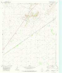
1980 Map of Chancellor
USGS Topo · Published 1980About this map
Industrial and rail infrastructure defines this portion of Pecos County, where the Atchison Topeka and Santa Fe railroad cuts a diagonal line through the landscape. The small settlement of Chancellor serves as a central point along the tracks, situated near a station well and a series of gravel operations. The terrain is dominated by the prominent rise of Triple Butte to the northeast, while the seasonal drainage of Acebuche Draw carves a path through the arid flats. This 1980 survey captures the region during a period of active resource extraction and utility expansion, evidenced by numerous Drill Holes, Gravel Pits, and a prominent Pipeline crossing the northern territory. A lonely Roadside Park and a Radio Tower near the center of the sheet reflect the intersection of trans-continental travel and communication in this West Texas corridor.
Find a feature on this map
10 named features on this map. Tap any name to fly to it.
Don’t see what you’re looking for? This feature index may not catch every label — zoom into the map to look around manually.
Map Details
Editions of this 1980 Chancellor Map
This is the sole edition of this map. No revisions or reprints were ever made.
Other maps of this area

1929 · Hovey
USGS Topo · 1:125,000

1954 · Fort Stockton
USGS Topo · 1:250,000

1958 · Fort Stockton
USGS Topo · 1:250,000

1970 · Belding SW
USGS Topo · 1:24,000

1970 · Deep Well Ranch SE
USGS Topo · 1:24,000
1970 · Belding
USGS Topo · 1:24,000

1973 · Fort Stockton
USGS Topo · 1:250,000
1980 · Cave Mesa NE
USGS Topo · 1:24,000

1980 · Cave Mesa
USGS Topo · 1:24,000

1980 · Hovey
USGS Topo · 1:24,000