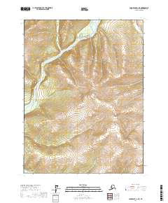
2017 Map of Chandalar A-1 NE
USGS Topo · Published 2017About this map
The East Fork Chandalar River winds through this northern interior landscape, carving a broad valley defined by significant elevation changes. This 2017 U.S. Geological Survey topographic study illustrates the hydrological network of the Yukon-Koyukuk region, where Crater Creek and its smaller tributary branch, Crater Cr, drain the surrounding high country. The map provides a precise layout of the Public Land Survey System for the area, marking the boundaries of t28n r2e, t28n r3e, t27n r2e, and t27n r3e. This remote Alaskan terrain is largely unpopulated, with no marked roads or settlements, focusing instead on the complex contour lines and natural drainage patterns of the river system.
Find a feature on this map
7 named features on this map. Tap any name to fly to it.
Don’t see what you’re looking for? This feature index may not catch every label — zoom into the map to look around manually.
Map Details
Editions of this 2017 Chandalar A-1 NE Map
This is the sole edition of this map. No revisions or reprints were ever made.
Other maps of this area

1951 · Chandalar
USGS Topo · 1:250,000

1951 · Christian
USGS Topo · 1:250,000

1956 · Chandalar
USGS Topo · 1:250,000

1956 · Christian
USGS Topo · 1:250,000

1964 · Chandalar
USGS Topo · 1:250,000
1990 · Chandalar A-1
USGS Topo · 1:63,360
1990 · Christian B-6
USGS Topo · 1:63,360
1990 · Chandalar B-1
USGS Topo · 1:63,360
1990 · Christian A-6
USGS Topo · 1:63,360
2017 · Chandalar A-1 NW
USGS Topo · 1:25,000