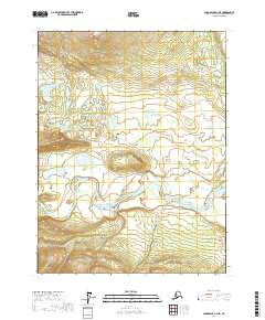
2017 Map of Chandalar A-3 NE
USGS Topo · Published 2017About this map
Teedriinjik River meanders across this northern landscape, forming a complex network of braided channels and river bends near the settlement of Caro. This area of the Yukon-Koyukuk Census Area is characterized by low-lying wetlands and numerous water bodies, including Mary Lake and Kobuk Lake, which are situated in the broader river basin. The drainage patterns of small tributaries like Mickey Cr, Flunn Cr, and Flat Cr reveal the intricate hydrological network that defines this interior Alaska region. The terrain transitions from these water-rich lowlands toward higher elevations indicated by the dense contour lines in the northern and southern portions of the quadrangle. The map provides a detailed view of the township and range system, including t27n r3w and t28n r2w, which organize this largely undeveloped landscape around the historic presence at Caro.
Find a feature on this map
11 named features on this map. Tap any name to fly to it.
Don’t see what you’re looking for? This feature index may not catch every label — zoom into the map to look around manually.
Map Details
Editions of this 2017 Chandalar A-3 NE Map
This is the sole edition of this map. No revisions or reprints were ever made.
Other maps of this area

1951 · Chandalar
USGS Topo · 1:250,000

1956 · Chandalar
USGS Topo · 1:250,000

1964 · Chandalar
USGS Topo · 1:250,000
1990 · Chandalar A-2
USGS Topo · 1:63,360
1990 · Chandalar B-3
USGS Topo · 1:63,360
1990 · Chandalar A-3
USGS Topo · 1:63,360
1990 · Chandalar B-2
USGS Topo · 1:63,360
2017 · Chandalar A-2 SW
USGS Topo · 1:25,000
2017 · Chandalar B-2 SW
USGS Topo · 1:25,000
2017 · Chandalar A-2 NW
USGS Topo · 1:25,000