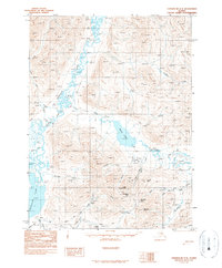
1990 Map of Chandalar C-3
USGS Topo · Published 1990About this map
The Chandalar River drainage defines this remote subarctic landscape, where industrial efforts in the Brooks Range are marked by the presence of the Chandalar Mine and multiple unnamed Mines. Transportation in this challenging environment relied heavily on seasonal routes like the Winter Trail and a designated Landing Strip near the mining operations. The rugged topography is punctuated by prominent summits such as Crystal Peak and McLellan Peak, which overlook a network of high-elevation water bodies including Squaw Lake and Little Squaw Lake. Significant drainage systems like the McNett Fork and Squaw Creek carve through the terrain, illustrating the hydrologic patterns that dictated access for early 20th-century prospectors and bush pilots in the Alaskan interior.
Find a feature on this map
29 named features on this map. Tap any name to fly to it.
Don’t see what you’re looking for? This feature index may not catch every label — zoom into the map to look around manually.
Map Details
Editions of this 1990 Chandalar C-3 Map
This is the sole edition of this map. No revisions or reprints were ever made.
Other maps of this area

1951 · Chandalar
USGS Topo · 1:250,000

1956 · Chandalar
USGS Topo · 1:250,000

1964 · Chandalar
USGS Topo · 1:250,000
1971 · Chandalar C-4
USGS Topo · 1:63,360
1971 · Chandalar B-4
USGS Topo · 1:63,360
1971 · Chandalar D-4
USGS Topo · 1:63,360
1990 · Chandalar B-3
USGS Topo · 1:63,360

1990 · Chandalar C-2
USGS Topo · 1:63,360
1990 · Chandalar D-2
USGS Topo · 1:63,360
1990 · Chandalar B-2
USGS Topo · 1:63,360