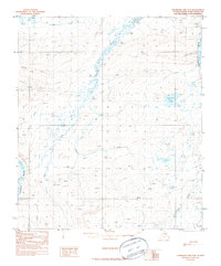
1987 Map of Chandler Lake D-3
USGS Topo · Published 1987About this map
The Tuluga River flows through this North Slope landscape, flanked by an extensive network of seasonal transportation routes. Compiled from 1978 aerial photography, this map records the essential infrastructure for traversing the Arctic terrain during the late twentieth century, including several segments of the Winter Trail and a remote Landing Strip near the Anaktuvuk River. The geography is defined by high elevation points and significant water bodies like Ahaliorak 1148 T Lake, situated beneath a prominent Ridge. To the southwest, the Siksikpuk River and its various tributaries, such as the West Fork and East Fork, create a complex drainage pattern through the foothills, while Terrace Creek marks the southeastern corner of the quadrangle.
Find a feature on this map
10 named features on this map. Tap any name to fly to it.
Don’t see what you’re looking for? This feature index may not catch every label — zoom into the map to look around manually.
Map Details
Editions of this 1987 Chandler Lake D-3 Map
This is the sole edition of this map. No revisions or reprints were ever made.
Other maps of this area

1951 · Chandler Lake
USGS Topo · 1:250,000

1952 · Umiat
USGS Topo · 1:250,000

1955 · Umiat A-4
USGS Topo · 1:63,360

1955 · Umiat A-3
USGS Topo · 1:63,360

1956 · Chandler Lake
USGS Topo · 1:250,000

1956 · Umiat
USGS Topo · 1:250,000

1964 · Chandler Lake
USGS Topo · 1:250,000

1964 · Umiat
USGS Topo · 1:250,000
1971 · Chandler Lake C-2
USGS Topo · 1:63,360

1971 · Umiat A-2
USGS Topo · 1:63,360