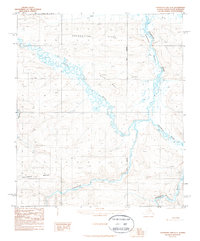
1987 Map of Chandler Lake D-4
USGS Topo · Published 1987About this map
The Ayiyak River meanders across this northern landscape, carving a complex network of oxbows and marshy lowlands within the Ninngolik Valley. The terrain is defined by dramatic flat-topped elevations, notably Hatbox Mesa and the prominent Grandstand Ridge, which provide significant relief against the river drainage systems. This 1987 provisional survey captures a remote wilderness where the only evidence of human presence is a solitary Cabin and the path of a Winter Trail crossing the northeastern corner near the Chandler River. Geodetic control is marked by the Umiat Meridian, which bisects the quadrangle. The map illustrates the characteristic Arctic drainage patterns of the Siksikpuk River, where seasonal water flow and permafrost influence the shifting geography of the North Slope.
Find a feature on this map
10 named features on this map. Tap any name to fly to it.
Don’t see what you’re looking for? This feature index may not catch every label — zoom into the map to look around manually.
Map Details
Editions of this 1987 Chandler Lake D-4 Map
This is the sole edition of this map. No revisions or reprints were ever made.
Other maps of this area

1951 · Chandler Lake
USGS Topo · 1:250,000

1952 · Umiat
USGS Topo · 1:250,000

1955 · Umiat A-4
USGS Topo · 1:63,360

1955 · Umiat A-5
USGS Topo · 1:63,360

1955 · Umiat A-3
USGS Topo · 1:63,360

1956 · Chandler Lake
USGS Topo · 1:250,000

1956 · Umiat
USGS Topo · 1:250,000

1964 · Chandler Lake
USGS Topo · 1:250,000

1964 · Umiat
USGS Topo · 1:250,000
1987 · Chandler Lake C-4
USGS Topo · 1:63,360