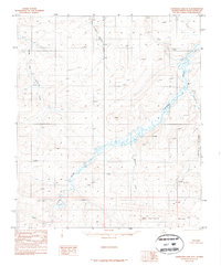
1987 Map of Chandler Lake D-5
USGS Topo · Published 1987About this map
The Ayiyak River meanders across this northern landscape, forming the central geographic spine of this Arctic interior survey. This 1980s data represents a time when the Bureau of Land Management was still formalizing land lines across vast unsurveyed tracts of the North Slope. The drainage patterns are intricate, with Mammoth Creek flowing into the main river from the south while East Fork Ninuluk Creek and South Fork Ninuluk Creek dominate the northwestern quadrant. A notable topographic landmark is the Hatbox Mesa in the southeast, a distinct landform rising above the surrounding river valleys. The map also records early survey markers like ST 60190 and ST 60191, which provided critical reference points for mapping this terrain before modern GPS technology. The lack of any roads or buildings emphasizes the wilderness character of the region during this era.
Find a feature on this map
9 named features on this map. Tap any name to fly to it.
Don’t see what you’re looking for? This feature index may not catch every label — zoom into the map to look around manually.
Map Details
Editions of this 1987 Chandler Lake D-5 Map
This is the sole edition of this map. No revisions or reprints were ever made.
Other maps of this area

1951 · Ikpikpuk River
USGS Topo · 1:250,000

1951 · Chandler Lake
USGS Topo · 1:250,000

1951 · Killik River
USGS Topo · 1:250,000

1952 · Umiat
USGS Topo · 1:250,000

1955 · Umiat A-4
USGS Topo · 1:63,360

1955 · Umiat A-5
USGS Topo · 1:63,360

1956 · Chandler Lake
USGS Topo · 1:250,000

1956 · Killik River
USGS Topo · 1:250,000

1956 · Ikpikpuk River
USGS Topo · 1:250,000

1956 · Umiat
USGS Topo · 1:250,000