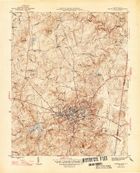
1947 Map of Chapel Hill
USGS Topo · Published 1947About this map
Chapel Hill and Carrboro form the central urban core of this postwar survey, a landscape defined by the convergence of the Southern railroad and several radial roads. The university influence is evident through University Lake to the southwest and the Horace Williams Airport located just north of the primary settlements. Beyond the growing town centers, the terrain transitions into a patchwork of rural homesteads and named hills like Iron Mine Hill and Bald Mtn. Local history is preserved in the numerous family cemeteries and small rural institutions, such as Tilley Cem, Partin Cem, and Morris Grove Sch, which dot the drainages of Bolin Creek and Morgan Creek. The eastern edge of the map follows the Orange Co Durham Co boundary, where Eastwood Lake sits as a notable water feature near the growing road network.
Find a feature on this map
59 named features on this map. Tap any name to fly to it.
Don’t see what you’re looking for? This feature index may not catch every label — zoom into the map to look around manually.
Map Details
Editions of this 1947 Chapel Hill Map
2 editions found
Other maps of this area

1943 · Durham South
USGS Topo · 1:62,500

1946 · Chapel Hill
USGS Topo · 1:24,000

1947 · Chapel Hill
USGS Topo · 1:31,680

1951 · Farrington
USGS Topo · 1:24,000

1951 · Durham South
USGS Topo · 1:62,500

1951 · Durham North
USGS Topo · 1:62,500

1953 · Raleigh
USGS Topo · 1:250,000

1953 · Greensboro
USGS Topo · 1:250,000

1954 · Greensboro
USGS Topo · 1:250,000

1954 · Raleigh
USGS Topo · 1:250,000