
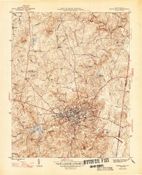
1947 Map of Chapel Hill
USGS Topo · Published 1947About this map
Chapel Hill and Carrboro serve as the central anchors of this 1947 edition, showing the university town as it expanded shortly after the war. The map documents the localized aviation hub at Horace Williams Airport and the critical water resource at University Lake. Beyond the developing town centers, the landscape is defined by family-named heights and rural communities like Blackwood, Eubanks, and Calvander. Genealogists will find significant value in the documentation of numerous country churches and cemeteries, such as Mt Sinai Ch and the Partin Cem. The presence of Iron Mine Hill and Meadow Flats hints at the varied land use and resource extraction history that preceded the mid-century suburban shift. Traces of old transportation networks remain visible through labels like Old Field Road and the Southern railroad line cutting through the terrain.
Find a feature on this map
48 named features on this map. Tap any name to fly to it.
Don’t see what you’re looking for? This feature index may not catch every label — zoom into the map to look around manually.
Map Details
Editions of this 1947 Chapel Hill Map
2 editions found
Other maps of this area

1943 · Durham South
USGS Topo · 1:62,500

1946 · Chapel Hill
USGS Topo · 1:24,000

1951 · Farrington
USGS Topo · 1:24,000

1951 · Durham South
USGS Topo · 1:62,500

1951 · Durham North
USGS Topo · 1:62,500

1953 · Raleigh
USGS Topo · 1:250,000

1953 · Greensboro
USGS Topo · 1:250,000

1954 · Greensboro
USGS Topo · 1:250,000

1954 · Raleigh
USGS Topo · 1:250,000

1962 · Greensboro
USGS Topo · 1:250,000