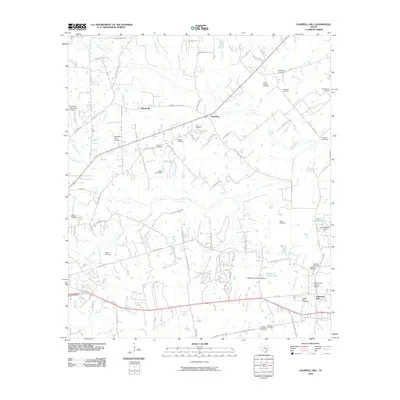
2010 Map of Chappell Hill
USGS Topo · Published 2010About this map
Chappell Hill and its Main Street Historic District anchor the southeast corner of this Washington County landscape, where the terrain is defined by a dense network of family-named cemeteries and small rural settlements. The map documents a transition from the agricultural heritage of Wiedeville and Earlywine to modern developments such as the Brenham Municipal Airport and Brenham Golf Course in the west. A complex drainage system feeds into New Year Creek and Woodward Creek, supporting several local reservoirs including Stolz Lake and Research Farms Lake. For genealogists, the sheer density of burial sites—ranging from the Masonic Cemetery and Baptist Hill Cemetery to private family grounds like Willingham Cemetery and Atkinson Cemetery—provides an exceptional record of the area's ancestral residents and community structure at the start of the 21st century.
Find a feature on this map
82 named features on this map. Tap any name to fly to it.
Don’t see what you’re looking for? This feature index may not catch every label — zoom into the map to look around manually.
Map Details
Editions of this 2010 Chappell Hill Map
This is the sole edition of this map. No revisions or reprints were ever made.
Other maps of this area

1914 · Gay Hill
USGS Topo · 1:62,500

1914 · Navasota
USGS Topo · 1:62,500

1930 · Brenham
USGS Topo · 1:62,500

1954 · Austin
USGS Topo · 1:250,000

1956 · Hempstead
USGS Topo · 1:62,500

1956 · Brenham
USGS Topo · 1:62,500

1958 · Washington
USGS Topo · 1:24,000

1959 · Gay Hill
USGS Topo · 1:24,000

1959 · Independence
USGS Topo · 1:24,000
1961 · Daniels
USGS Topo · 1:24,000