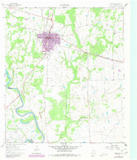
1956 Map of Hempstead
USGS Topo · Published 1956About this map
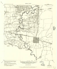
The Brazos River meanders sharply along the border of Waller and Washington counties, its shifting course evident in numerous oxbows and an Old River Bed Mexican Bend. This 1919-era survey, reprinted for civil use, documents a rural landscape centered on cotton production and rail transport, anchored by the Hempstead P.O. and the Houston and Texas Central Railroad. Plantation life and early education are visible through specialized sites like the Riverside Plantation School and industrial structures such as Woods Gin and Stones Gin. The map reveals a network of country churches including Second Corinth Church and Pleasant Grove Church, alongside small family-named landmarks like Clarks Farm and Carlisle Farm. Significant river crossings, such as the Hempstead-Beeville Wagon Bridge, illustrate the vital connections between these farming communities and neighboring Austin County.
Find a feature on this map
53 named features on this map. Tap any name to fly to it.
Don’t see what you’re looking for? This feature index may not catch every label — zoom into the map to look around manually.
Map Details
Editions of this 1956 Hempstead Map
This is the sole edition of this map. No revisions or reprints were ever made.
Historical Maps of Prairie View Through Time
7 maps found