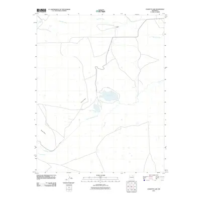
2010 Map of Charette Lake
USGS Topo · Published 2010About this map
Charette Lake and its smaller counterpart, Upper Charette Lake, anchor this high-plains landscape in Colfax County. The terrain is defined by the prominent Charette Mesa and Apache Mesa, which overlook a network of seasonal water bodies and managed irrigation systems, including the substantial Charette Lake Diversion Canal. This area illustrates the critical role of water management in the arid West, where natural features like Laguna Yeso and creeks such as Sweetwater Creek and Ocate Creek are vital resources.
Find a feature on this map
11 named features on this map. Tap any name to fly to it.
Don’t see what you’re looking for? This feature index may not catch every label — zoom into the map to look around manually.
Map Details
Editions of this 2010 Charette Lake Map
This is the sole edition of this map. No revisions or reprints were ever made.
Other maps of this area

1954 · Raton
USGS Topo · 1:250,000

1956 · Miami
USGS Topo · 1:62,500

1958 · Raton
USGS Topo · 1:250,000

1964 · Wagon Mound
USGS Topo · 1:24,000

1964 · Colmor
USGS Topo · 1:24,000

1964 · Pinon Hills
USGS Topo · 1:24,000

1966 · Mora Ranch
USGS Topo · 1:24,000
1966 · Cerro Negro
USGS Topo · 1:24,000
1966 · La Chata Crater
USGS Topo · 1:24,000
1966 · Charette Lake
USGS Topo · 1:24,000