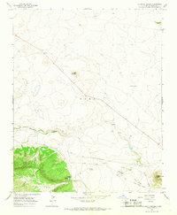
1966 Map of La Chata Crater
USGS Topo · Published 1968About this map
Santa Fe Trail (Wagon Mound Cutoff) cuts a historical diagonal across this high-plains landscape, marking a legacy of nineteenth-century trade routes in Mora County. The terrain is dominated by the volcanic profile of La Chata Crater and the rugged northern slopes of the Turkey Mountains. Water sources like Diamond A Spring and drainage systems including Gallinas Creek and Ciruela Creek define the ranching viability of the region, anchored by the Diamond A Ranch. The mid-1960s era represented here shows a remote territory where aviation infrastructure like the Diamond A Landing Strip provided essential connectivity. Land use is further characterized by the elevated Jarosa Mesa and topographical markers such as the Levy SW Base, reflecting the integration of traditional cattle country with modern surveying and navigation needs.
Find a feature on this map
14 named features on this map. Tap any name to fly to it.
Don’t see what you’re looking for? This feature index may not catch every label — zoom into the map to look around manually.
Map Details
Editions of this 1966 La Chata Crater Map
This is the sole edition of this map. No revisions or reprints were ever made.
Other maps of this area

1892 · Watrous
USGS Topo · 1:125,000

1894 · Watrous
USGS Topo · 1:125,000

1954 · Santa Fe
USGS Topo · 1:250,000

1954 · Raton
USGS Topo · 1:250,000

1958 · Raton
USGS Topo · 1:250,000

1958 · Santa Fe
USGS Topo · 1:250,000

1964 · Wagon Mound
USGS Topo · 1:24,000

1964 · Mogote Hills
USGS Topo · 1:24,000

1964 · Colmor
USGS Topo · 1:24,000

1966 · Mora Ranch
USGS Topo · 1:24,000