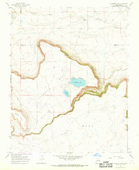
1966 Map of Charette Lake
USGS Topo · Published 1968About this map
The Santa Fe Trail (Mountain Route) cuts through the northwestern corner of this landscape, tracing a historic path across the high plains of Mora and Colfax counties. The terrain is dominated by the dramatic escarpment of Charette Mesa, which overlooks the winding course of Ocate Creek to the south. Central to this area are Charette Lake and Upper Charette Lake, which are supported by the Charette Lake Diversion Canal, illustrating early efforts to manage water in this arid environment. To the north, the small settlement at Bedford Ranch sits near the headwaters of Sweetwater Creek. The map shows a transition from the broad, flat heights of Apache Mesa to the intricate drainages and seasonal water features like Laguna Yeso, providing a clear record of the area's ranching and transit history.
Find a feature on this map
14 named features on this map. Tap any name to fly to it.
Don’t see what you’re looking for? This feature index may not catch every label — zoom into the map to look around manually.
Map Details
Editions of this 1966 Charette Lake Map
This is the sole edition of this map. No revisions or reprints were ever made.
Other maps of this area

1954 · Raton
USGS Topo · 1:250,000

1956 · Miami
USGS Topo · 1:62,500

1958 · Raton
USGS Topo · 1:250,000

1964 · Wagon Mound
USGS Topo · 1:24,000

1964 · Colmor
USGS Topo · 1:24,000

1964 · Pinon Hills
USGS Topo · 1:24,000

1966 · Mora Ranch
USGS Topo · 1:24,000
1966 · Cerro Negro
USGS Topo · 1:24,000
1966 · La Chata Crater
USGS Topo · 1:24,000

1981 · Springer
USGS Topo · 1:100,000