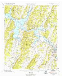
1942 Map of Charleston
USGS Topo · Published 1960About this map
Chickamauga Lake and the Hiwassee River define this 1942 landscape as the region adapted to the newly created reservoirs of the Tennessee Valley Authority. The twin settlements of Charleston and Calhoun sit at a critical crossing point where the Southern railroad and Lee Highway bridge the river, marking a hub of transport and commerce. The surrounding terrain is characterized by a series of parallel ridges, including Mc Minn Ridge and Mouse Creek Ridge, which dictate the placement of small communities and family landmarks.
Find a feature on this map
44 named features on this map. Tap any name to fly to it.
Don’t see what you’re looking for? This feature index may not catch every label — zoom into the map to look around manually.
Map Details
Editions of this 1942 Charleston Map
2 editions found
Other maps of this area

1886 · Cleveland
USGS Topo · 1:125,000

1892 · Cleveland
USGS Topo · 1:125,000

1895 · Cleveland
USGS Topo · 1:125,000

1901 · Cleveland
USGS Topo · 1:125,000

1935 · East Cleveland
USGS Topo · 1:24,000

1935 · Calhoun
USGS Topo · 1:24,000

1935 · Benton
USGS Topo · 1:24,000

1935 · Goodfield
USGS Topo · 1:24,000

1935 · Charleston
USGS Topo · 1:24,000
1935 · Birchwood
USGS Topo · 1:24,000