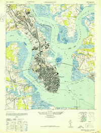
1948 Map of Charleston
USGS Topo · Published 1948About this map
The dense urban grid of Charleston is captured here during its mid-century industrial height, framed by the expansive waters of the Ashley River and the Cooper River. The northern neck of the peninsula shows heavy maritime and defense infrastructure, dominated by the Navy Yard and the U S Naval Reservation, while the historic city core terminates at the Battery. Harbor defenses including Fort Sumter, Castle Pinckney, and Fort Johnson guard the seaward approaches. Inland, the map reveals a series of distance-named settlements such as Sixmile House and Fourmile House, tracing the historical progression of travel north from the city. Significant burial grounds including Magnolia Cem and St Lawrence Cem occupy large tracts near the marshlands of Shipyard Creek, providing essential records for genealogical research in this coastal South Carolina hub.
Find a feature on this map
59 named features on this map. Tap any name to fly to it.
Don’t see what you’re looking for? This feature index may not catch every label — zoom into the map to look around manually.
Map Details
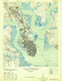
Editions of this 1948 Charleston Map
2 editions found
Other maps of this area

1919 · Ladson
USGS Topo · 1:21,120

1919 · Johns Island
USGS Topo · 1:21,120

1919 · The Jetties
USGS Topo · 1:21,120

1919 · Wadmelaw Island
USGS Topo · 1:62,500

1919 · Wando
USGS Topo · 1:21,120

1919 · Melgrove
USGS Topo · 1:21,120

1919 · Charleston
USGS Topo · 1:21,120

1919 · James Island
USGS Topo · 1:21,120

1919 · Fort Moultrie
USGS Topo · 1:21,120

1919 · Legareville
USGS Topo · 1:21,120
Featured Places
- Charleston, SC
- North Charleston, SC
- Mount Pleasant, SC
- Ashley Junction, North Charleston
- Daniel Jenkins Homes, North Charleston