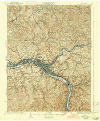
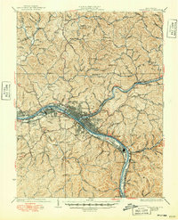
1935 Map of Charleston
USGS Topo · Published 1942About this map
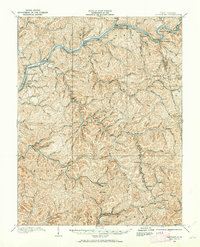
Industrial and residential development follows the deep curves of the Kanawha River and Elk River in this West Virginia valley during the mid-1930s. The city of Charleston and West Charleston serve as the central hub, supported by a dense network of transportation infrastructure including the New York Central RR and the Chesapeake and Ohio RR. The riverfront is heavily utilized, featuring the U S Navy Reservation near South Charleston and the emerging suburbs of Dunbar and Spring Hill.
Find a feature on this map
68 named features on this map. Tap any name to fly to it.
Don’t see what you’re looking for? This feature index may not catch every label — zoom into the map to look around manually.
Map Details
Editions of this 1935 Charleston Map
2 editions found
Other maps of this area

1897 · Kanawha Falls
USGS Topo · 1:125,000

1899 · Charleston
USGS Topo · 1:125,000

1900 · Kanawha Falls
USGS Topo · 1:125,000

1901 · Kanawha Falls
USGS Topo · 1:125,000

1906 · Kenna
USGS Topo · 1:62,500

1906 · Winfield
USGS Topo · 1:62,500

1906 · Walton
USGS Topo · 1:62,500
1907 · Kenna
USGS Topo · 1:62,500
1907 · Walton
USGS Topo · 1:62,500
1907 · Clendenin
USGS Topo · 1:62,500